Hurricane David hits Cocoa, September 3, 1979
Hurricane David made landfall near Stuart on September 3, 1979, then tracked north over Brevard County. Cocoa took tropical-storm-force sustained winds, hurricane-force gusts, widespread flooding, and significant damage to homes and groves. The recovery cost was an inflection point for Brevard's hurricane preparedness.
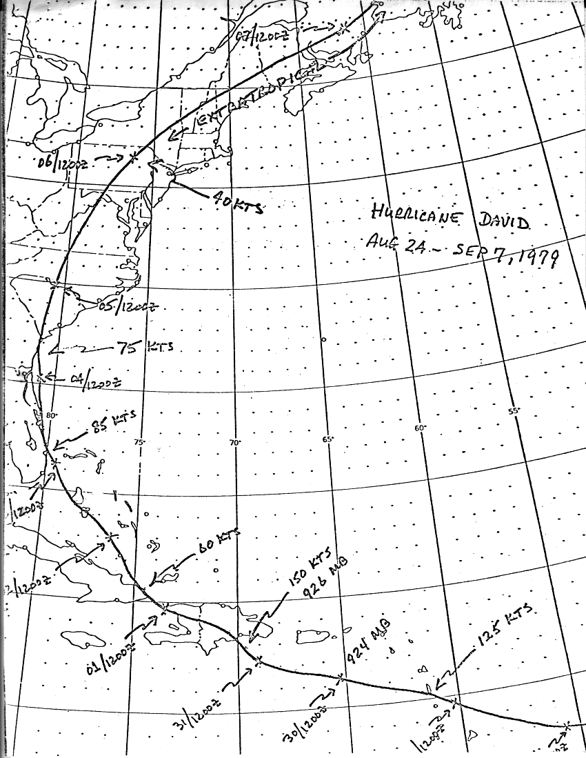
Hurricane David made U.S. landfall near Stuart, Florida on the evening of September 3, 1979, as a Category 2 hurricane with sustained winds of 100 mph. The storm then tracked north along the Florida east coast, weakening but still producing destructive winds across Brevard County through the night of September 3 and into the morning of September 4. Cocoa took tropical-storm-force sustained winds, hurricane-force gusts, widespread power outages, and substantial property damage. No deaths were attributed to David in Brevard County, but the property damage in Cocoa and Cocoa Beach combined totaled an estimated $40-60 million in 1979 dollars (roughly $180-275 million in 2026 dollars).
David was the strongest hurricane to hit the central Florida east coast since Hurricane Donna in 1960. It was also a wake-up call. Brevard County’s post-1960 buildout, most of the city of Cocoa Beach, much of Rockledge, most of Suntree and the early Viera planning, had occurred during a relatively storm-quiet period, and David exposed how much new construction had been built to inadequate hurricane standards.
David’s track
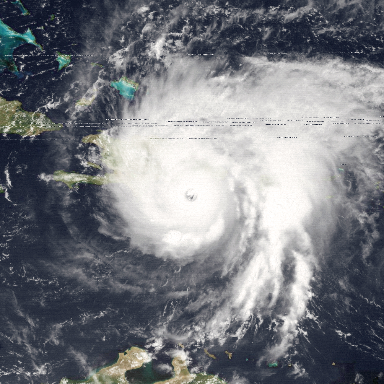
Hurricane David originated as a tropical disturbance off the coast of Africa in late August 1979. The storm rapidly intensified to Category 5 strength in the eastern Caribbean, with sustained winds reaching 175 mph as it passed south of Hispaniola on August 30. David caused catastrophic damage in Dominica (killing over 50), the Dominican Republic (killing approximately 2,000 in flash floods and structural collapses), and Haiti.
By the time David reached the U.S. Florida east coast, the storm had weakened substantially from its peak, interaction with Hispaniola’s mountains had disrupted the eyewall. The Florida landfall was Category 2 strength, not Category 5. The U.S. damage was severe but not the apocalyptic scenario that David’s Caribbean track had suggested.
The Florida landfall:
- September 3, 1979, approximately 6 p.m. EDT. Landfall near Stuart in Martin County, sustained winds 100 mph at the coast.
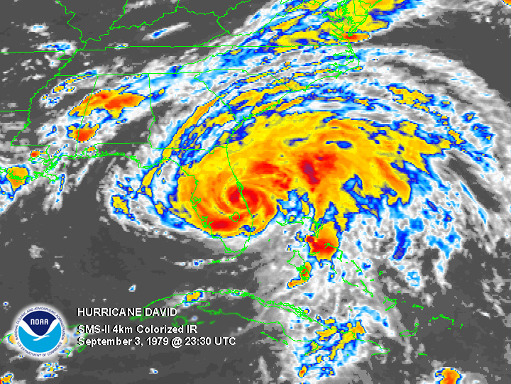
- Evening of September 3. Storm tracked north along the coast, weakening slightly but maintaining destructive intensity. Brevard County took hurricane-force gusts beginning approximately 9 p.m.
- Overnight September 3-4. Eye passed approximately 30 miles east of Cocoa Beach. Cocoa and Cocoa Beach received sustained tropical-storm-force winds (40-60 mph), gusts to approximately 80 mph, and 4-7 inches of rainfall.
- Morning of September 4. Storm continued north, weakening to tropical-storm strength as it tracked over north Florida and Georgia.
What Cocoa took
Brevard County emergency-management records and Florida Today coverage from September 4-10, 1979 document David’s effects on Cocoa:
Wind damage. Widespread tree damage, signage damage, and roof damage. The Cocoa Village historic district took moderate damage, several historic-building roofs lost shingles, awnings, and decorative trim. The Aladdin Theatre’s marquee was damaged. S.F. Travis Hardware lost some exterior signage but the building was intact. The Porcher House took roof damage that was repaired within three months.
Power outages. Florida Power & Light reported approximately 35,000 Brevard County customers without power at peak. Cocoa-area outages extended through September 4-7 in some neighborhoods; the citrus groves west of town were last to be re-energized.
Flooding. Storm surge in the Indian River Lagoon at Cocoa peaked at approximately 4 feet above normal high tide. Low-lying streets near the lagoon flooded; the Riverfront Park was inundated. Drainage was problematic in older neighborhoods with inadequate stormwater infrastructure.
Citrus damage. The remaining Brevard County citrus groves, already in declining numbers due to urban development and the 1962 freeze, took further damage. Estimated 15-20% fruit loss on remaining bearing groves, plus significant tree damage from wind. The recovery cost was a factor in the post-1979 acceleration of grove-to-housing conversions.
Cocoa Beach damage. The barrier island took heavier damage than the mainland. Beachfront condominiums and single-family homes built in the 1960s and 1970s, many to standards that were inadequate for 100-mph winds, sustained substantial damage. Several oceanfront buildings were declared structurally compromised. Cocoa Beach’s recovery cost was approximately three times the mainland Cocoa cost.
What David exposed
The post-1960 Brevard County building stock had been constructed under building codes that, in retrospect, were inadequate for Atlantic hurricane risk. The South Florida Building Code (which post-Andrew, in 1992, became a national reference for hurricane-zone construction) did not yet exist; Florida statewide building codes were lax; Brevard County’s adopted codes were modest.
David exposed several specific weaknesses:
- Roof tie-downs. Many Brevard houses built 1960-1979 had inadequate connections between roof trusses and wall framing. Roofs failed under uplift loads that proper tie-downs would have resisted.
- Garage doors. Common Brevard residential garage doors had no provisions for hurricane-force-wind loads; failure of a garage door causes interior overpressure that often pulls a roof off.
- Window protection. Hurricane shutters or impact-resistant glazing was rare in residential construction. Broken windows in David led to extensive interior damage and additional structural failures.
The post-David building-code response in Brevard was modest, meaningful code changes came after Hurricane Andrew in 1992, not after David in 1979, but David did prompt some local revisions and significantly increased public attention to hurricane preparedness.
The recovery
Brevard County emergency response in 1979 was led by the county emergency management office in coordination with the cities. The 1979 emergency-response system was less developed than current standards, the Stafford Act federal disaster framework was still relatively new (enacted 1974), FEMA had been established only in 1979 (April), and the coordination between federal, state, and county responders was less practiced.
Federal disaster assistance was approved for Brevard County (and several other Florida counties) on September 5, 1979. FEMA Individual Assistance and Public Assistance grants flowed to Brevard County residents and local governments through late 1979 and 1980. The federal share covered approximately $25 million of Brevard County’s recovery costs.
Insurance covered a portion of remaining costs. Property insurance penetration in Brevard County was relatively high by Florida standards (many of the post-1960 homeowners were NASA / military families with substantial insurance), but coverage gaps and underinsured-condominium situations on the barrier island meant several million dollars of damage was absorbed by individual property owners.
What David did not do
David did not produce the population-altering disaster that subsequent Florida hurricanes, Andrew (1992), Charley (2004), Wilma (2005), Irma (2017), Ian (2022), produced for their landfall areas. Brevard County’s population growth continued through the 1980s without significant David-induced slowdown.
David did not cause major civic-infrastructure loss in Cocoa. City Hall, the library, the schools, the historic district, all came through with manageable damage. The Riverfront Park (1960s and 1970s improvements) needed cleanup but no major rebuilding.
David also did not produce major loss of life in Florida; the U.S. death toll was approximately 15, all in scattered events outside Florida or in flooding away from the main landfall area. The contrast with David’s Caribbean death toll of approximately 2,000 is stark and reflects both better U.S. infrastructure and the chance fact that David weakened before Florida landfall.
David as a wake-up call
For Cocoa specifically, David was the first major hurricane experience of an entire generation of residents. The Brevard County population that had grown from 23,000 in 1950 to 272,000 in 1980 had largely arrived during a relatively storm-quiet period. David’s September 3-4, 1979 night was, for many Cocoa-area families, their first hurricane.
The post-1979 conversations about preparedness, hurricane shutters, evacuation routes, generator preparation, date partly from this experience. The Brevard County emergency-management infrastructure that responded to subsequent storms (the 1991 No-Name Storm, the 2004 hurricane sequence) was built on lessons that David exposed.
The next major hurricane to hit Brevard directly was Hurricane Erin in 1995, which made landfall in northern Brevard near Sebastian Inlet. Erin was a smaller storm than David but caused additional damage to a region that had not yet fully implemented post-David building-code improvements. The pattern repeated with the 2004 sequence (Charley, Frances, Jeanne).
Further Reading
Sources
- National Hurricane Center, NOAA, Hurricane David post-storm report, October 1979.
- Florida Today, hurricane coverage September 1-10, 1979 (microfilm and digital archives).
- Brevard County Emergency Management, post-storm damage assessments, September-October 1979.
- Federal Emergency Management Agency, Disaster Declaration FEMA-602-DR-FL, September 1979.
- Florida Power & Light, outage and restoration records for Brevard County, September 1979.
- Insurance Information Institute, historical hurricane damage estimates.
- Stuart Florida historical records on David landfall.
- South Florida Water Management District, post-David storm surge measurements.
- National Weather Service, climate and hurricane historical data, Brevard County.
As an Amazon Associate we earn from qualifying purchases.